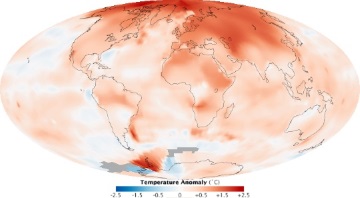
Climate Change is here, and is effecting many aspects of our communities: increased risk of wildfire, vegetation stress leading to disease and insect outbreaks, seal level rise, possibilities for increased risk of flooding and drought, and impacts on habitat are just some of the anticipated effects of a changing climate. Common Futures uses the latest AR-5 climate scenarios and regionally downscaled climate projections from major general circulation models (GCMs), coupled with a variety of landscape change models, to project anticipated impacts from climate change on a variety of indicators. Using the Envision alternative futures model, we can help you assess a variety of mitigation and adaptation strategies for coping with climate change.
Application areas include assessment of climate change impacts on:
The outcome of this process is a set of maps (GIS coverages) reflecting trajectories of change, expressed in a variety of representations (for example land use, land cover, zoning, water use) - customized to your specific needs, and a series of outcome metrics that reflect how well a given scenario acheives your goals.
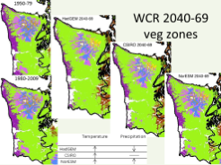
Understanding how anticipated climate change may affect the health, composition, and productivity of western Washington forests, and what adaptation strategies are likely to be successful?
Common Futures scientists worked with the State of Washington's Department of Natural Resources to develop a set of alternative future scenarios using best available climate projections, the dynamic biogeography model MC2, and forest productivity models, to characterize likely climate impact on western Washingoton forests.
A set of maps, indicating forest stand trajectories under a variety of climate scenarios, that will be used to explore strategies for adapting to climate change.